Thursday, October 30, 2014

Thursday and Friday Oct 30th and 31st Days 47 & 48


Jeopardy for Monday's test here - ( jeopardy )

Columbian Exchange (day 3)

Today students will be given more time to finish their Columbian Exchange annotation as well as their Cartography Timeline Project

OBJECTIVES: Given primary source material, as well as summary material related to the Columbian Exchange, students will be able to annotate and clearly summarize information into a cohesive paragraph describing the cause and effects of the Columbus landing in 1492.

Follow these steps:

1. Read the Columbian Exchange article and write a quick summary of what you read
2. Read the 2 intro articles
3. Read the Columbian Exchange article again, but this time annotate it
4. Fill-in the Graphic organizer
5. Fill-in the sentence frame sheet
6. Write a new Summary of the Article

Intro material

Read this short intro first -( Here )  then read this intro from Alfred Crosby ( Here ),

Main Article

Columbian Exchange Article  ( Here )

Worksheets/Graphic Organizer

Use these printouts in class ( Here ) or use a separate piece of paper for each activity
____________________________________________________________________

Here is a list of items and their due dates for this week:
Explorers Project:  (was due by Wed, so its late at this point)
Timeline Project: Electronically submitted by Thursday (per 1,3,5) Friday (per 0,2)

We will play jeopardy in class Thursday and Friday, and I will post the jeopardy for review over the weekend.(Check back here on Friday for the Jeopardy review game pdf)


_____________________________________________________________________

MAPPING TEST -Moved to Monday

______________________________________________________________________
Enjoy your "trick or treating"

Tuesday, October 28, 2014

Tuesday & Wednesday Oct 28th & 29th Day 45 & 46

Columbian Exchange

Today we will begin the Columbian Exchange article annotation.

OBJECTIVES: Given primary source material, as well as summary material related to the Columbian Exchange, students will be able to annotate and clearly summarize information into a cohesive paragraph describing the cause and effects of the Columbus landing in 1492.

Follow these steps:

1. Read the Columbian Exchange article and write a quick summary of what you read
2. Read the 2 intro articles
3. Read the Columbian Exchange article again, but this time annotate it
4. Fill-in the Graphic organizer
5. Fill-in the sentence frame sheet
6. Write a new Summary of the Article

Intro material

Read this short intro first -( Here )  then read this intro from Alfred Crosby ( Here ),

Main Article

Columbian Exchange Article  ( Here )

Worksheets/Graphic Organizer

Use these printouts in class ( Here ) or use a separate piece of paper for each activity
____________________________________________________________________

Here is a list of items and their due dates for this week:
Explorers Project: 
(per 1,3,5 ) Print out and bring Tuesday or finish Tuesday and bring Wed in your non-block day)
(per 0,2 ) Print out and bring Wed or finish Wed and bring Thursday in your non-block day)

Timeline Project: Electronically submitted by Thursday (per 1,3,5) Friday (per 0,2)

We will play jeopardy on the day of the test during the first part of the block schedule
_____________________________________________________________________

MAPPING TEST THURSDAY/FRIDAY

Monday, October 27, 2014

Monday Oct 26th Day 44

Finishing the History of Map Making

Today we will finish the History of Map Making presentation up to Columbus and Magellan. The remaining information on the presentation will be available on the presentation pdf found ( Here )

In preparation for tomorrow, please print out these 3 pages to be used in class ( Here )
Columbian Exchange Article  ( Here )

Here is a list of items and their due dates for this week:
Modern Map Making article: Due today
Explorers Project: 
(per 1,3,5 ) Print out and bring Tuesday or finish Tuesday and bring Wed in your non-block day)
(per 0,2 ) Print out and bring Wed or finish Wed and bring Thursday in your non-block day)

Timeline Project: Electronically submitted by Thursday (per 1,3,5) Friday (per 0,2)

We will play jeopardy on the day of the test during the first part of the block schedule
_____________________________________________________________________

MAPPING TEST THURSDAY/FRIDAY

______________________________________________________________________

Objectives for today: Presented with an informational presentation, students will be able to connect the various developments with the art of cartography and the extended travel expeditions of various explorers of the 15th and 16th centuries through a detailed timeline.


Columbus in the Bahamas
San Salvador Island 

Friday, October 24, 2014

Friday Oct 24th Day 43

HOME COMING RALLY AND GAME

Today is Home Coming Rally schedule. The shortened period was used for students to work on their assignments and projects.
Here are the due dates of these items:
Modern Map Making Article - Due Monday
Explorers Project - Due end of 1st Day Block period (Tues/Wed)
Timeline Project - Due end of 2nd Day Block period (Thurs/Fri)

Mapping Test - will be Thurs/Fri of Next week. I plan on developing another Jeopardy game review to be played before the test.

Wednesday, October 22, 2014

Wednesday Thursday Oct 22nd & 23rd Day 41& 42


History of Map Making and the Explorers that use them


Today classes will continue with the History of Map Making presentation started in class last week.

The presentation will cover the historical events, people and technological developments of all things cartography. At the conclusion of the presentation students will be able to: Describe the evolution of map making advancements through various stages of development, listing the people and products developed through the various stages, and describe the role they played in mapping our world.

In addition to the presentation, students will be given time to work on their Timeline, the Modern Map Making article and their Explorers Project.


Monday, October 20, 2014

Tuesday Oct 21, Day 40

Today in class you should be working on a few things:
Navigation & Tools article and questions
Your Timeline Project (which should include information from the Navigators and Tools Article)
The next article Modern Map Making, link here ( Link ) as well as on yesterday's blog page
Or you can start doing research for the Explorers Project

EXPLORERS PROJECT

The Explorers Project will assign an explorer to each student.The Explorer you are assigned is the  explorer with the same number as your current seat.
 i.e student sitting at seat 11 gets Juan Ponce de Leon. The directions for the project are listed on Yesterday's Blog page as well as the link to where you can find information about your explorer.
Links to various resources:

Explorers Project - Directions Page: ( Link )
Explorers Name and links to informational websites: ( Link )
Explorers Information website:( Link )
All about Explorers:( Link )
Notable Explorers: ( Link )
Conquistadors: ( Link )

Explorers assigned to your seat number (only periods 1, 3 & 5)
1- Sir Francis Drake
2- Sir Walter Raleigh
3- Marco Polo
4- Ferdinand Magellan
5- Christopher Columbus
6- Francisco Pizarro
7 -Amerigo Vespucci
8- Vasco Nunez de Balboa
9- Vasco da Gama
10 -Sir Humphrey Gilbert
11- Juan Ponce de Leon
12- Sir Richard Grenville
13 -Sir John Hawkins
14 Francisco Vasquez de -Coronado
15 -Sir Martin Frobisher
16 -Hernando De Soto
17- Sir Richard Hawkins
18 -Hernando Cortes
19 -Bartolomeu Dias
20 -Pedro Alvares Cabral
21 -Giovanni da Verrazzano
22- Gaspar Corte Real
23- John Cabot
24- Sebastian Cabot
25 -Jacques Cartier
26 -Henry Hudson
27 -Jacques Marquette
28 -Samuel de
29 -Cabeza de Vaca
30 -Panfilo de Narvaez Spanish
31 -Fray Marcos de Niza
32 -Alonso Alvarez de Pineda
33 -Juan de Onate Spanish
34 -Lucas Vazquez de Ayllon
35 -Juan Rodriguez Cabrillo
36 -Louis Joliet

Monday Oct 20th Day 39

Explorers Project

Here is the link to the Jeopardy game we played in class as a review for the test - (Jeopardy)

Today we assign students their Explorer for the Explorers Project - (Direction sheet)

In addition, the timeline project is continuing this week. Contributing to the info on your timeline is the Modern Map Making article  (Article Link here) be sure to answer the questions at the end and add the info to your timeline.

We also went over the test results for the Lat/Long/Seasons test. The curve was a 55, and the magic number (to not re-take the test) was a 41. Remember, you have 1 week to re-take the test.

Wednesday, October 15, 2014

Thursday & Friday Oct 16th & 17th Day 37,38

Latitude/Longitude/Seasons

Today we will review the materials for the Latitude/Longitude/Season test, before we actually take the test during the Block time period.

Objectives: Separated into 3 groups, student will work cooperatively assisting team members to determine the correct answer to possible test questions.

We will start the class playing jeopardy as a review game.
The test will cover all the material we learned about Longitude and Latitude (including determining the the distance in miles between lines,figuring out scale, knowing the significant lines of Latitude and Long, etc) as well as Seasons (the dates of the seasons, the locations of direct and indirect rays of the sun and the impact that has on weather and daylight) and lastly Time Zones (the way time is determined, and how to add or subtract time based on the location of a city).


One of the sources of information for this test came from the Seasons ppt -

get the PowerPoint version here (PowerPoint version)
get the PDF version here (PDF version)

When students finish the test, they should continue to work on their Map Making Timeline, or the Navigators and Tools article.

Tuesday, October 14, 2014

Tuesday & Wednesday Oct 14th &15th Days 35, 36

Island Project/Article/Timeline


Today students will work on their Island project, the Early Map Making Article, and the Navigators & Tools Article.

OBJECTIVES:
- Given and article covering historical Explorers and the tools they used for navigation, students will be able to describe using a summary format, the various advancements in exploration technology, and the effect those advancements had on the distance, duration and accuracy of travel.

Navigators and Tools -
ABSTRACT: Upon completion of this article student will be able to describe, using a summary format (answering the questions), the various advancements in exploration tools/technology, and the effect those advancements/tools had on the distance, duration, and accuracy of travel. In addition, students will be able to list in a timeline format the various people that played a major role in the advancement of cartography and exploration -  (Article and Questions)


                                                                 Timeline - 
Begin the process of making a timeline of events, people and advancements in cartography and exploration. Use the Google Drive Presentation tools to include: a line, pictures of people, tools,etc and a brief description of what the item is or who the  person was, and what impact they had on the history of mapping.- (Timeline directions )


example

Sunday, October 12, 2014

Monday Oct 13th Day 34

HISTORY OF MAP MAKING


Today students will be introduced to the History of Map Making.

OBJECTIVES:
- students will be able to describe in detail using a historical timeline the various advancements in the art of cartography from early Babylonian Society to modern day.

-Given a chromebook with the Google Drive applications loaded and working, students will be able to construct a historical timeline of map development, including significant events of exploration.

Today's History of Mapping presentation - (PowerPoint version)
(PDF version)

TEST

There will be a test this week (Thursday/Friday) on Season/Latitude and Longitude/and Time Zones.
We will have a review activity on Tuesday/Wed as part of that block.

Wednesday, October 8, 2014

Thursday and Friday Oct 9th & 10th Days 33, 34


HISTORY OF MAP MAKING


Today students will continue on their island activity for the Cartographer project. In addition, we will watch the West Wing episode regarding the use of the Mercator Projection vs the Peterson Projection.
Students will be given an opportunity to compare the two maps and draw conclusions regarding their differences. In addition students will get the "early Map making article and will be given time to read and complete the questions to further their understanding of the history of Cartography.

OBJECTIVES:
-Given a first hand account of an explorer visiting a new land, students will be able to draw to scale a accurate depiction of the island, place it within the stated lines of  Latitude and Longitude and describe the appropriate vegetation and animal life that would occur on such an island.

-Given an article describing the early developments of Cartography, students will be able to accurately analyze and answer text dependent questions to demonstrate understanding of the articles content.

Mercator vs Peters

West Wing on Mercator vs Peters  - (watch the video)

Mercator vs Peters Projections -website animation - (watch the animated debate)

Original "Blue Marble" picture taken from the moon - (Orientation?)


Reading Assignment on Early Map Making

Early Map Making article - (Article and Questions)
Early Map Making article - (Student answer sheet)

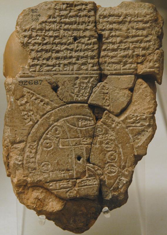
http://www.ancient-wisdom.co.uk/Images/babylonian_worldmap.jpg
Oldest Known Map
http://upload.wikimedia.org/wikipedia/commons/thumb/f/f0/Claudius_Ptolemy-_The_World.jpg/1024px-Claudius_Ptolemy-_The_World.jpg
Ptolemy's world map


Tuesday, October 7, 2014

Tuesday-Wednesday Oct 7th, 8th Day 31, 32

Introduction to the Unit


We are beginning our Unit on the History of Cartography (map making). In this unit students will learn about the challenges early map makers had in representing an accurate picture of their surroundings. Many early map makers had limited to no technology at their disposal and had to develop a way to represent various land features, coast lines, mountains, etc. This led to many early maps being incredibly limited and  inaccurate. These inaccuracies led  many expeditions to unknown parts of the world and resulted in some very destructive behaviors as well as new found places and people. This unit will cover various explorers, and the lands they mapped-out for future exploration.

Objectives and outcomes:
*Given a blank piece of paper, the student will experience the challenges of a cartographer in producing and accurate map based solely on verbal instructions.
*Given a fictitious land mass to view, students will use only cardinal direction in describing the details to a amateur cartographer in producing a map.
*Given a description of a fictitious island, students will use recently acquired mapping skills to produce an accurate replication of the described land.
* Given a blank piece of paper students will be able to draw a relatively accurate map of a familiar place they know very well.

Does this look very accurate?


Steps to Map Making - ( Map Making Steps )
Cartographer project -  ( Project Directions )

Monday, October 6, 2014

Monday Oct 6th

Journal Writing
What did you do over the break


Objectives:

Given a scavenger hunt directions sheet with multiple latitude and longitude coordinates, students will be able to  find the locations listed and spell out the location of the hidden treasure with 100% accuracy.
Scavenger Hunt directions sheet - ( scavenger hunt )

Test your knowledge - 

Latitude and longitude practice site - ( fun practice)

Map Coordinates Practice - ( fun practice )

Time Zones practice site - ( fun practice )